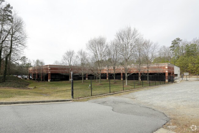
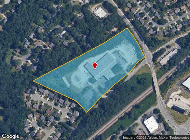
Property Record
2707 Main St, Duluth, GA 30096
Property Detail
2707 Main St
7-202-043
Water Works
Warehouse
WATER WORKS RD
AE
Gwinnett
13121C0094G
Georgia
2025
9.91 AC
2025
Duluth/Suwanee/Buford
050234
Atlanta
44,932 SF
Atlanta-Sandy Springs-Roswell, GA
NEARBY LISTINGS FOR SALE OR LEASE
DEMOGRAPHICS near 2707 Main St
1 mile
3 mile
5 mile
2024 Total Population
10,012
66,589
203,877
2029 Population
10,540
69,339
213,596
Pop Growth 2024-2029
+ 5.27%
+ 4.13%
+ 4.77%
Average Age
40
39
38
2024 Total Households
3,670
24,698
74,197
HH Growth 2024-2029
+ 5.53%
+ 4.29%
+ 4.78%
Median Household Inc
$97,545
$86,808
$82,401
Avg Household Size
2.70
2.70
2.70
2024 Avg HH Vehicles
2.00
2.00
2.00
Median Home Value
$365,219
$380,323
$396,752
Median Year Built
1995
1995
1995
Nearby Places
Map Layers
Map Styles
 Street
 Aerial
Transit
 Traffic
 Biking
Places
Listings with unknown addresses are not visible on the map
- Restaurants
- Banks
- Shops
- Fitness
- Groceries
SALE & LEASE HISTORY
LISTING DATE
SALE/LEASE

Oct 16, 2019
For Lease
Nov 01, 2017
For Sale
May 21, 2018
For Lease
May 09, 2017
For Sale
May 03, 2021
For Sale
May 03, 2021
For Lease
Jan 18, 2017
For Lease
Feb 07, 2018
For Lease
Feb 07, 2018
For Sale
Nearby Properties
Address
Land Use
TOTAL SIZE
Lot Size
Zoning
Address
Land Use
TOTAL SIZE
Lot Size
Zoning
1,457,980 SF
98.78 AC
MUR
Address
Land Use
TOTAL SIZE
Lot Size
Zoning
794,057 SF
78.64 AC
PUD
Address
Land Use
TOTAL SIZE
Lot Size
Zoning
508,494 SF
38.74 AC
RM13
Address
Land Use
TOTAL SIZE
Lot Size
Zoning
482,658 SF
17.05 AC
MUR
Address
Land Use
TOTAL SIZE
Lot Size
Zoning
393,913 SF
25.93 AC
RM13
Address
Land Use
TOTAL SIZE
Lot Size
Zoning
523,344 SF
40.47 AC
RM
Address
Land Use
TOTAL SIZE
Lot Size
Zoning
450,815 SF
45.79 AC
RM10
Address
Land Use
TOTAL SIZE
Lot Size
Zoning
359,241 SF
21.02 AC
PMUD
Address
Land Use
TOTAL SIZE
Lot Size
Zoning
471,807 SF
69.50 AC
R100
Address
Land Use
TOTAL SIZE
Lot Size
Zoning
423,004 SF
47.93 AC
RM
Address
Land Use
TOTAL SIZE
Lot Size
Zoning
285,038 SF
1.93 AC
MUR
Address
Land Use
TOTAL SIZE
Lot Size
Zoning
491,482 SF
41.72 AC
C1
Address
Land Use
TOTAL SIZE
Lot Size
Zoning
620,975 SF
8.10 AC
PUD
Address
Land Use
TOTAL SIZE
Lot Size
Zoning
334,841 SF
28.14 AC
RM13
Address
Land Use
TOTAL SIZE
Lot Size
Zoning
341,506 SF
36.69 AC
C1
Address
Land Use
TOTAL SIZE
Lot Size
Zoning
372,904 SF
11.64 AC
PUD
Address
Land Use
TOTAL SIZE
Lot Size
Zoning
609,495 SF
6.28 AC
PUD
Address
Land Use
TOTAL SIZE
Lot Size
Zoning
253,169 SF
8.74 AC
RM24
Address
Land Use
TOTAL SIZE
Lot Size
Zoning
377,960 SF
29.70 AC
RM13
Address
Land Use
TOTAL SIZE
Lot Size
Zoning
365,351 SF
30.70 AC
OI
Address
Land Use
TOTAL SIZE
Lot Size
Zoning
418,495 SF
22.06 AC
PUD
Address
Land Use
TOTAL SIZE
Lot Size
Zoning
287,824 SF
31.59 AC
RM
Address
Land Use
TOTAL SIZE
Lot Size
Zoning
217,080 SF
49.32 AC
M1
Address
Land Use
TOTAL SIZE
Lot Size
Zoning
263,285 SF
22.50 AC
RM
Address
Land Use
TOTAL SIZE
Lot Size
Zoning
252,043 SF
22.03 AC
RM
Address
Land Use
TOTAL SIZE
Lot Size
Zoning
256,640 SF
28.59 AC
RM
Address
Land Use
TOTAL SIZE
Lot Size
Zoning
1,052,800 SF
51.40 AC
M2
Address
Land Use
TOTAL SIZE
Lot Size
Zoning
326,904 SF
46.73 AC
OI
Address
Land Use
TOTAL SIZE
Lot Size
Zoning
304,001 SF
32 AC
PUD
Address
Land Use
TOTAL SIZE
Lot Size
Zoning
235,586 SF
16.21 AC
PUD
The World's #1 Commercial Real Estate Marketplace
Connect with us
© 2026 CoStar Group
The information above has been obtained from sources believed reliable. While we do not doubt its accuracy we have not verified it and make no guarantee, warranty or representation about it. It is your responsibility to independently confirm its accuracy and completeness. Any projections, opinions, assumptions, or estimates used are for example only and do not represent the current or future performance of the property. The value of this transaction to you depends on tax and other factors which should be evaluated by your tax, financial, and legal advisors. You and your advisors should conduct a careful, independent investigation of the property to determine to your satisfaction the suitability of the property for your needs.